
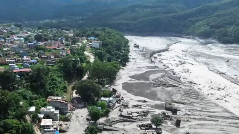
The flooding on Wednesday (August 26) morning hit Rasuwa, Nuwakot, Dhading, Gorkha and Chitwan, with Timure and other settlements near the Nepal-China border suffering heavy damage. Kathmandu/New Delhi: Nepal’s northern border has faced another major natural disaster after a sudden flood swept through parts of Rasuwa and affected several districts downstream.
Another major incident occurred in 2024 at Thame in Khumbu Pasang Lhamu Rural Municipality of Solukhumbu district. The 2016 flood in the Kodari area was also among the major disasters in the Himalayan border region.
Dharmaraj Upreti, executive chief of Nepal’s National Disaster Risk Reduction and Management Authority, said the broader pattern of changes in the high Himalayan region could offer an explanation for such incidents. Officials have also said the source of Wednesday’s Trishuli flood appears to have been on the Tibetan side rather than within Nepal, similar to last year’s flooding in the Rasuwa area. Basant Adhikari, director of the Disaster Studies Centre at Tribhuvan University’s Institute of Engineering, Pulchowk Campus, said the nature of the event suggests a possible avalanche that may have blocked the flow of water. He also said that glacial lake outbursts and avalanches have been identified as causes in several earlier floods in the region. Sudip Thukari, an assistant professor at Tribhuvan University, said glacial lake outbursts and avalanches are seasonal and geographical risks along the Nepal-China border, particularly in the Tibet region. He said many glacial lakes in the high Himalayas are fed continuously by glacier meltwater. Such natural disasters cannot be prevented, according to Thukari, but better monitoring and advance warnings can reduce the loss of life and property. He said Nepal needs stronger government-level coordination with China for disasters that originate in the Tibetan region. He said satellite stations could help monitor remote areas where there are no human settlements and where information cannot easily be passed through people on the ground. Thukari also said authorities could identify high-risk areas and consider moving settlements away from riverbanks and other vulnerable locations. Keeping new settlements away from areas with known flood risks, he said, is one of the most effective ways to reduce future losses.
The geography of the Himalayan border region plays a major role in the risks faced by communities living on the Nepal side. The area has glaciers, glacial lakes and steep valleys, while settlements, roads, bridges and hydropower projects are located further downhill. Changes in glaciers and glacial lakes can create conditions in which large volumes of water reach lower areas within a short time. He attributed it to rising temperatures and the changes taking place in the region over time. The sudden flow then entered Nepal and moved through the river system. Senior meteorologist and Department of Hydrology and Meteorology spokesperson Vibhuti Pokharel has urged caution over drawing a conclusion about the cause at this stage. Authorities are still trying to establish what happened, and the available information is not enough to confirm one particular explanation. Satellite analysis is needed to establish what happened. Nepal’s northern border region has some of the country’s highest Himalayan terrain. Across the border lies the Tibetan Plateau, while glaciers and glacial lakes are located above steep valleys that carry water towards Nepal. During the monsoon, heavy rainfall adds another risk. Changes in glaciers, avalanches and sudden releases of water can send water, rocks, mud and sand into lower areas. Communities living along rivers can then face the effects of an event that started much higher in the mountains. He explained that settlements, roads, bridges, hydropower projects and other infrastructure have been built on the steep Nepalese side of the mountains. When an avalanche occurs in Tibet or a glacial lake bursts, water can travel downhill and cause damage in these populated areas. Such incidents have occurred several times in the past. If the amount of water exceeds what the natural dam holding a lake can contain, the lake can suddenly burst and release water. An avalanche falling into a glacial lake can also displace water and send it over the lake’s natural barrier. Earthquake tremors can change the condition of a lake, while prolonged rainfall can increase the water level. A failure of the lake or its natural dam can then cause a sudden surge of water. A sudden flood there damaged dozens of houses. A glacial lake burst on the Tibetan side and sent floodwater into Nepal, causing heavy damage to buildings in Kodari and Tatopani, the Arniko Highway and the Upper Bhotekoshi hydropower project. Nepal has begun using early warning systems in some areas. These systems can monitor water levels and the condition of glacial lakes and their natural dams and provide real-time information. Early information can give people living downstream more time to move to safer areas. The challenge becomes more difficult when the source of the disasters lies across an international border. Such monitoring would give downstream communities more time to prepare for a sudden flood. Nepal has begun installing warning systems in some river catchments, but experts say their use in the high Himalayan region is still at an early stage.
A flood that originates in Nepal can be monitored through the country’s own systems, but a cross-border event requires information to reach Kathmandu before the water arrives.
Videos of the flood showed the river level rising by around 15 to 20 metres compared with normal conditions.
In the case of Wednesday’s flood, Adhikari said an assessment suggested that an avalanche had blocked water at Lende Khola. There was no clear information before the flood about the stream being blocked or the water level falling, he said. Thukari said small and large seasonal incidents involving glacial lakes and avalanches have occurred in the region over the years. Government reports said the flood gathered stones, soil and sand as it moved downhill, increasing its destructive force.
Floods and avalanches caused by the Himalayan terrain are not new to Nepal. He described Wednesday’s event as an unusually large one. Studies at the time found that a glacial lake had burst in the upper catchment area of Lende Khola. Roads, bridges, a power plant, populated areas and other infrastructure around the Bhotekoshi River were damaged.
Rasuwa also suffered a major flood last year, causing heavy loss of life and damage to property.
