
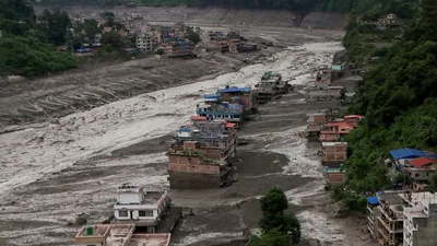
A day after the deadly Nepal flash floods, scientists and disaster-response agencies continued to work out what had caused the wall of water, mud and debris that tore through the Himalayan river valleys along the China -Nepal border on August 26. The working hypothesis remains an ice-rock avalanche — a large chunk of a glacier breaking away and cascading down — but what set that avalanche off is still under examination.
What it had first logged as a magnitude 4.4 earthquake — briefly assumed to be the trigger — was reclassified as a magnitude 5.2 landslide.
“Additional analysis of nearby seismic stations, long period seismic waves, and satellite imagery led to the determination that the seismic event was instead a glacial collapse and debris flow, and that no earthquake had occurred,” the USGS said. “A lake covering an area of approximately 0.11 square kilometres has formed due to the obstruction of the Lhende Khola’s flow in the upstream area, about 18 kilometres above the Rasuwagadhi border point,” the authority said on X. In other words, the tremor that officials in Kathmandu had first suspected of triggering the flood was the collapse itself. A second, related hazard emerged the same evening as Nepal and China warned of two lakes that have developed on either side of their border and threaten to burst in a region still grappling with the catastrophic flood. Nepal’s National Disaster Risk Reduction and Management Authority warned that a lake had formed upstream on the Lhende Khola after the debris flow blocked the river’s course. “Given the risk of a potential major flood, all individuals in the downstream areas are urged to exercise necessary vigilance and remain on high alert. The concern is a familiar one in the region: an ice-and-debris dam of this kind is inherently unstable, and its sudden failure can send a second surge through the same valley that has just been devastated.
The single sharpest development on Thursday came from the US Geological Survey (USGS), which revised its initial reading of the event.
In a peer-reviewed study published only weeks before the disaster in the journal Global and Planetary Change, a team led by Gunjan Silwal of Newcastle University — including a co-author from ICIMOD — mapped glacier change in the Langtang catchment, the Nepali basin immediately south of where the August 26 collapse originated. It found that glacierised areas above 4,000 metres in the catchment had been warming at 0.31°C per decade — roughly five times the global average — and that the region had lost more than 40% of the ice cover mapped at the end of the Little Ice Age.
Neera Shrestha Pradhan, water and disaster-risk-reduction lead at ICIMOD, said the immediate need was for community-based early warning systems that could operate across borders. This event is a hard reminder that in areas where such disasters are more likely, communities need to stay alert and stay prepared for the unforeseen,” she said. The underlying science has also been sharpening. Most significantly for events of the kind now under investigation, the paper identified fragmentation and disconnection of high-elevation ice — the same process suspected in the Rasuwa collapse — as the emerging dominant mode of glacier retreat in the region, with what its authors described as implications for “associated geohazards. “In this case, a cross-border early warning system could be a strong example of cooperation between the two countries. Our experience shows that providing information alone is not enough. Communities also need to be aware about how to translate this information and prepare themselves to act on it without panicking.
